Yang Xu
yang.ls.xu@polyu.edu.hk
181 Chatham Road South, Hung Hom, Kowloon, Hong Kong

I am an Associate Professor in the Department of Land Surveying and Geo-Informatics (LSGI) at The Hong Kong Polytechnic University. My research lies at the intersection of GIScience, Transportation, and Urban Informatics. Leveraging big data, my work focuses on the quantification and modeling of human activities in cities, aiming to reveal their linkage with urban and technological developments, and their impact on future economic, social and transportation systems. Before joining PolyU, I worked as a joint postdoctoral associate at the MIT Senseable City Lab and the Singapore-MIT Alliance for Research and Technology (SMART), where I focused on human mobility mining and modeling based on large scale urban datasets. (CV • Google Scholar • ResearchGate • ORCID • Twitter)
We have an excellent Master of Science Program in Urban Informatics and Smart Cities at PolyU. The program will start receiving applications through this portal from October, 2023 to April, 2024. More information of the program can be found here. We welcome you to apply!

PROFESSIONAL POSITIONS
Associate Professor, Department of Land Surveying and Geo-Informatics, The Hong Kong Polytechnic University (2023 - Present)
Assistant Professor, Department of Land Surveying and Geo-Informatics, The Hong Kong Polytechnic University (2017 - 2023)
Postdoctoral Associate, MIT Senseable City Lab & SMART Centre, Singapore (2016/06 - 2017/09)
Research Assistant, Oak Ridge National Laboratory (ORNL), USA (2013 - 2015)
EDUCATION
Ph.D., Geographic Information Science, University of Tennessee, Knoxville, US (2011 - 2015)
M.S., Geographic Information Science, Wuhan University, China (2009 - 2011)
B.S., Remote Sensing and Photogrammetry, Wuhan University, China (2005 - 2009)
WHAT'S NEW
March 2022: Our students won the Third Prize in Huawei APAC ICT Competition. Congratulations to the Polynomia Team!
March 2022: Check my CPGIS invited talk on "Understanding human mobility in a dynamic and changing world: A dual perspective of urban residents and visitors".
Jan 2022: Our paper published in Tourism Management receives the IFITT 2022 Journal Paper of the Year Award (1st Place)!
Jan 2022: Our project video, Urban Tour, is released!
Have problem accessing YouTube? Use this channel: https://www.bilibili.com/video/BV1ii4y1R7of
Dec 2021: Our students won the first prize of the 2021-22 Huawei ICT Competition Hong Kong.
July 2021: Our paper "Beyond Distance Decay: Discover Homophily in Spatially Embedded Social Networks" is published in Annals of the American Association of Geographers.
July 2021: Our paper "Short-Term Forecast of Bicycle Usage in Bike Sharing Systems: A Spatial-Temporal Memory Network" is published in IEEE Transactions on Intelligent Transportation Systems.
May 2021: Check my latest talk at GeoInsider on "手机大数据视角下的城市人群移动模式与交互特征 (Using cellphone big data to measure human mobility and interactions in cities)".
Jan 2021: Our paper published in Annals of Tourism Research receives the IFITT 2021 Journal Paper of the Year Award (2nd Place)!
Dec 2020: Our project video, Tourism Network, is released!
Have problem accessing YouTube? Use this channel: https://www.bilibili.com/video/BV1M5411V7ft
Oct 2020: "Singapore Calling" - A collaborative research project with the MIT Senseable City Lab, is an honorable mention in the Data Design category of FastCompany 2020 Innovation by Design Awards!
Nov 2018: The kickoff video of our project, Shared Bikes, is released!
Have problem accessing YouTube? Use this channel: https://www.bilibili.com/video/av36450369

Impact of Covid-19 on Tourist Travel Behavior
We analyze a large-scale LBS navigation dataset that captures travel activities of domestic inbound visitors in Jeju, Korea in the first nine months of 2020. A collection of regression models are introduced to quantify the dynamic effects of local and national COVID-19 indicators on their travel behavior. Results suggest that behavior of inbound travelers was jointly affected by pandemic severity locally and remotely. The impacts of the pandemic did not diminish over time but produced heterogeneous effects on travels with different trip purposes.
Conducted at: The Hong Kong Polytechnic University
Publications: Tourism Management (2022);
Movement Predictability of Urban Tourists
How well can we predict travelers' movements at tourism destinations? By analyzing cellphone big data of nearly 100,000 international travelers who visited South Korea in 2018, we build machine and deep learning models to quantify their movement predictability, assess the impact of lengty of stay and activeness in travel patterns on prediction accuracy, and reveal the models' predictive power over movements at differnt spatial scales (intra-city vs. inter-city).
Conducted at: The Hong Kong Polytechnic University
Project Video: YouTube, bilibili
Publications: Computers, Environment and Urban Systems (2021)
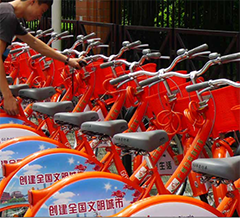
Shared Bikes
Bike sharing systems are an important part of today's urban transport ecosystems. In this project, we conduct data driven analysis to understand how these systems are used in cities (dockless & station-based), and how ridership is influenced by urban form and built environment. Meanwhile, by leveraging historical travel data and environmental observations, we develop advanced deep learning algorithms to support fine-grained and short-term travel demand forecast.
Conducted at: The Hong Kong Polytechnic University
Project Video: YouTube, 腾讯视频, bilibili
Publications: IEEE ITS (2021); CEUS (2019)
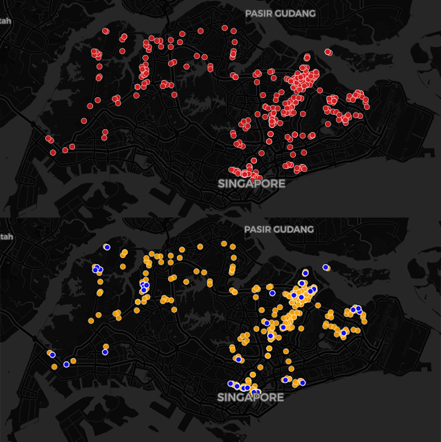
Spatial and Social Network Segregation in Cities
We put forward a computational framework based on coupling large scale information on human mobility, social network connections, and people’s socioeconomic status, to provide a breakthrough in our understanding of the dynamics of spatiotemporal and social-network segregation in cities. The framework can be used to depict segregation dynamics down to the individual level, and meanwhile, provide aggregate measurements at the scale of places and cities, and their evolution over time.
Conducted at: The Hong Kong Polytechnic University; MIT Senseable City Lab
Project Website: http://senseable.mit.edu/singapore-calling
Publications: AAAG (2021); Journal of The Royal Society Interface (2019); BBVA (2019)
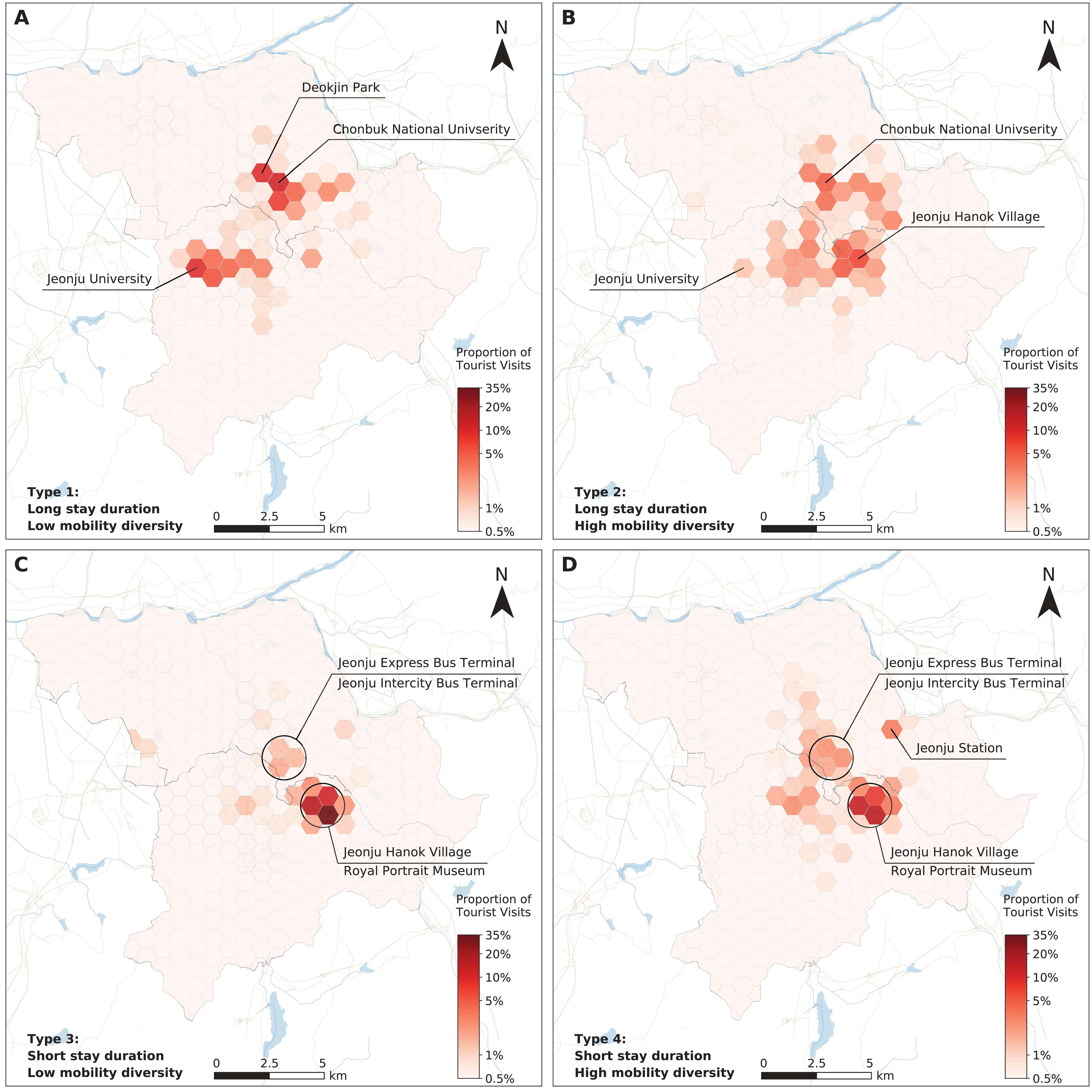
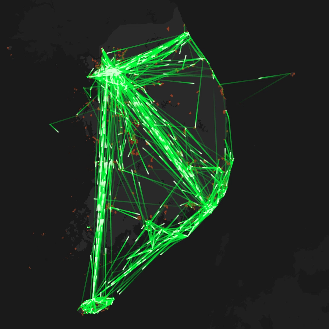
A Multidimensional View of Tourist Mobility Patterns in Cities
By analyzing mobile phone trajectories of international travelers to three different cities in South Korea (Jeonju, Gangneung and Chuncheon), we introduce nine mobility indicators to capture different facets of tourist travel behavior (e.g., duration of stay in a city, spatial extent of activities, location visited and trips conducted, and mobility diversity), and examine their statistical properties across cities. An eigendecomposition approach is then introduced to better understand the interdependency of these mobility indicators and inherent variations among individual travelers.
Conducted at: The Hong Kong Polytechnic University
Publications: Computers, Environment and Urban Systems (2021)
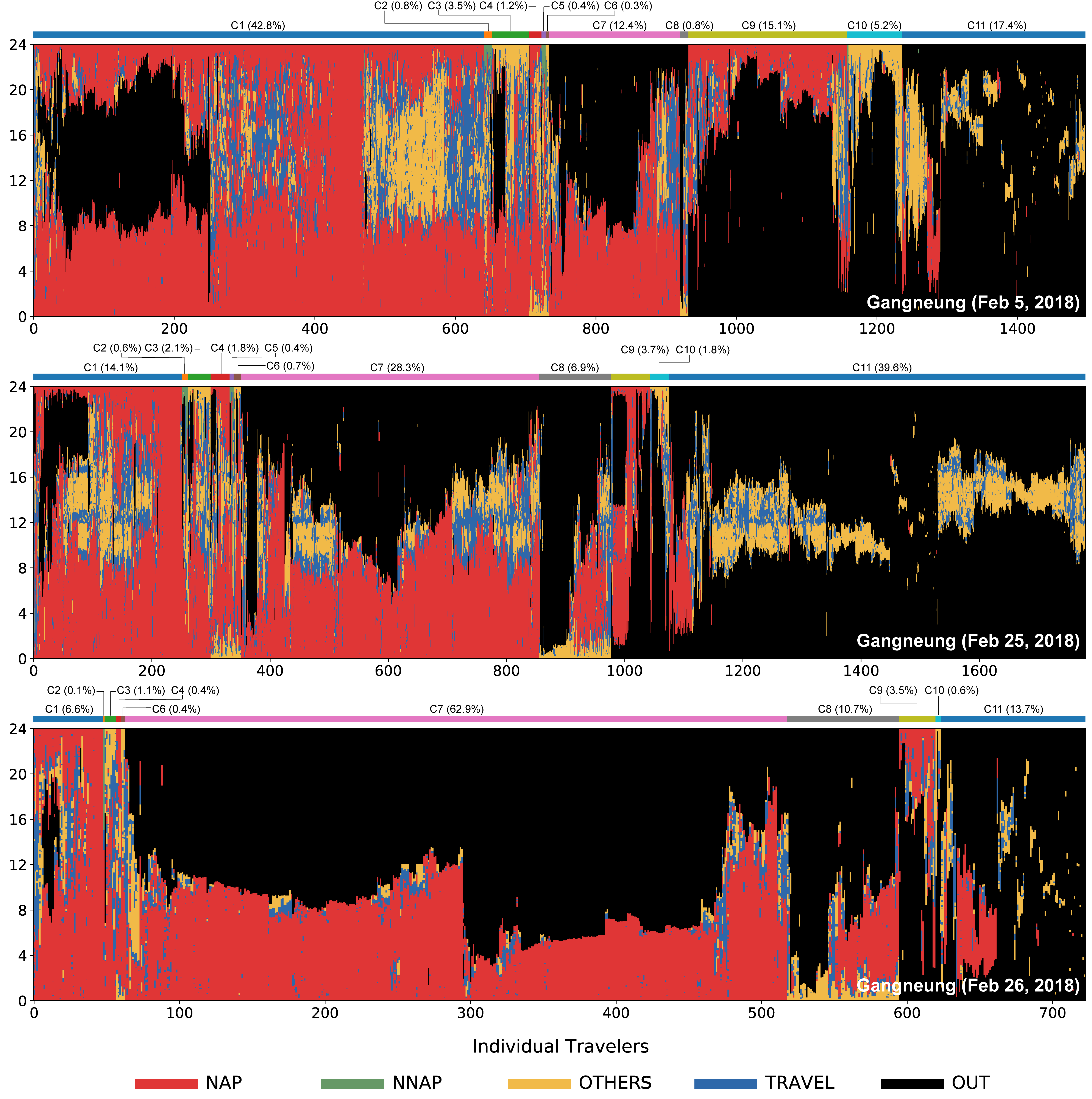
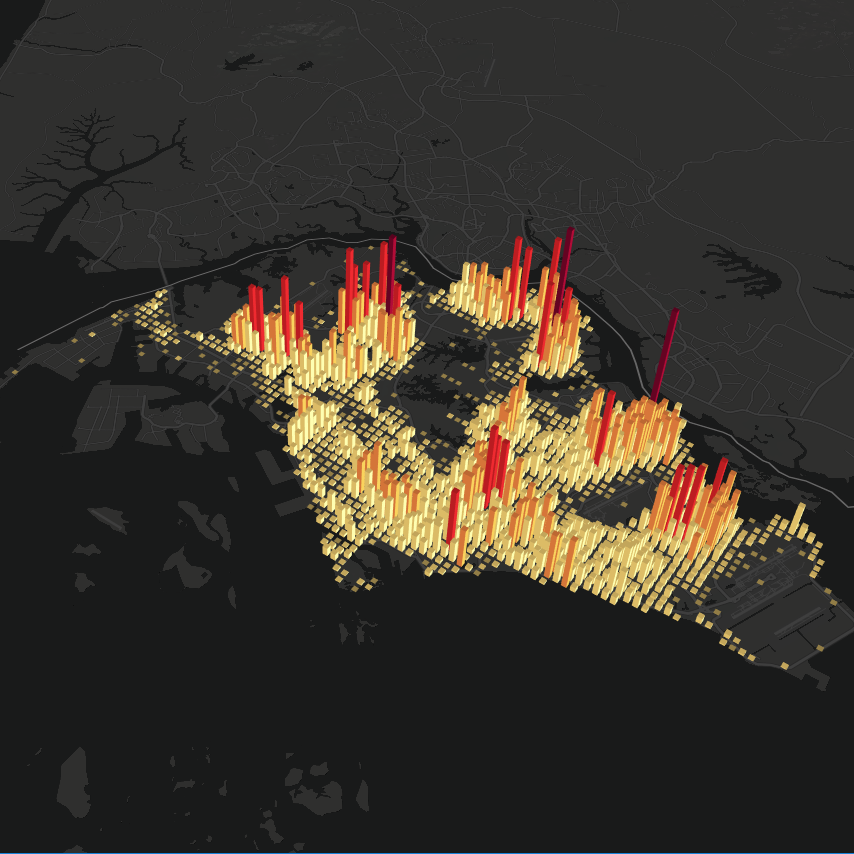
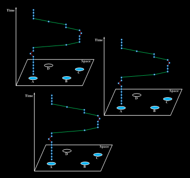
Tourism Geography Through the Lens of Time Use
By using a large-scale mobile phone data set collected in three cities in South Korea (Gangneung, Jeonju, and Chuncheon), we develop a computational framework to enable accurate quantification of tourist time use, the visualization of their spatiotemporal activity patterns, and systematic comparisons across cities. The framework consists of several approaches for the extraction and semantic labeling of tourist activities, visual-analytic tools (time use diagram, time–activity diagram) for examining their time use, as well as quantitative measures that facilitate day-to-day comparisons.
Conducted at: The Hong Kong Polytechnic University
Publications: Annals of the American Association of Geographers (2020)
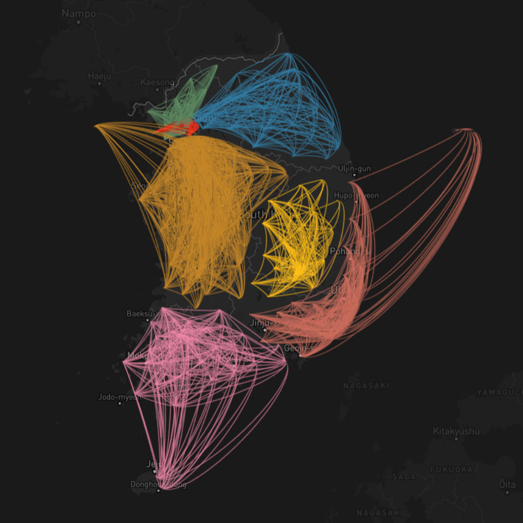
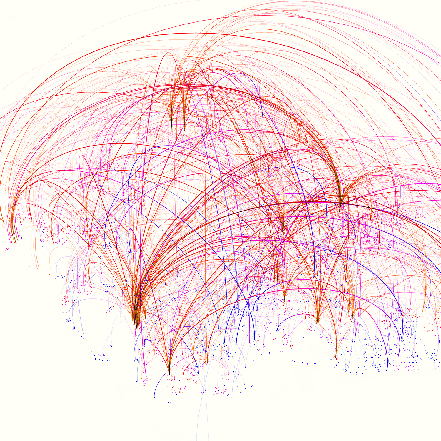
Tourism Network
We demonstrate how large-scale tourist mobility data can be linked with network science approaches to better understand tourism destinations and their interactions. By analyzing a mobile positioning dataset that captures the nationality and movement patterns of foreign tourists to South Korea, we employ a few metrics to quantify the network properties of tourism destinations, aiming to reveal the collective dynamics of tourist movements and key differences across nationalities.
Conducted at: The Hong Kong Polytechnic University
Project Video: YouTube, 腾讯视频, bilibili
Publications: Tourism Management (2020)
Big Data Veracity: A Mobile Phone Data Perspective
Mobile phone data are valuable resources for mobility research. However, observations in the data are usually associated with positional inaccuracy, which hinders accurate estimations of phone users' mobility characteristics. In this project, we examine different forms of location uncertainty in mobile phone data, and discuss how they would impact and giude the ways we process and analyze the data. Our research calls for more attention to the "veracity" issue in data driven mobility research, and broader implications to urban and geographic knowledge discovery.
Conducted at: The Hong Kong Polytechnic University
Publications: Annals of the American Association of Geographers (2020)
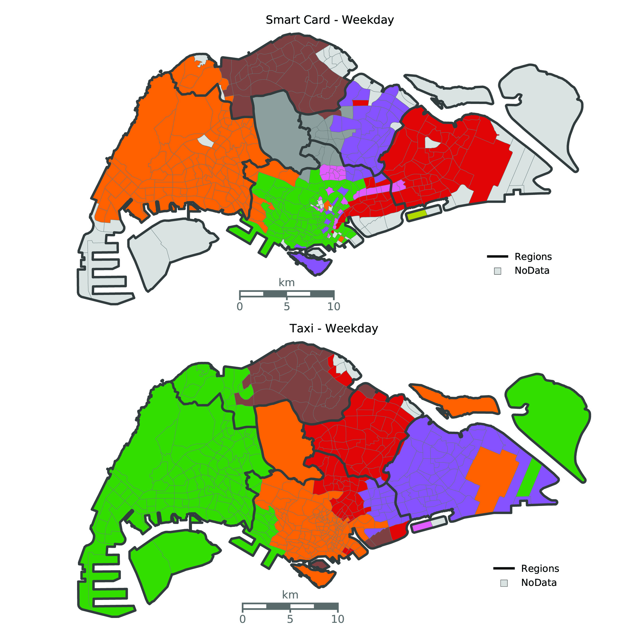
Comparative Urban Analytics
The explosion of massive mobility datasets (e.g., taxi trajectories, smart card transactions, mobile phone data) has generated new opportunities for urban research. Yet, there are increasing concerns about data representativeness and whether the knowledge and insights can be genenalized across cities. To this end, the project aims to perform intra- and inter-city comparisons to discover universal mechanisms and social-cultural differences that shape human behaviour in cities.
Conducted at: The Hong Kong Polytechnic University; SMART
Publications: Journal of Transport Geography (2018)
Human Mobility and Socioeconomic Status
How do people belonging to different social classes move around in a city, and whether they use urban spaces in different ways? In this research, we propose an analytical framework, by coupling large scale mobile phone and urban socioeconomic datasets ( e.g., housing price, travel survey, census data), to better understand human mobility patterns and their relationships with travelers' socioeconomic status.
Conducted at: MIT Senseable City Lab
Publications: Computers, Environment and Urban Systems (2018)
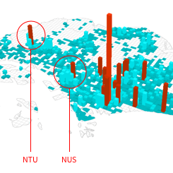
Friendly Cities: Quantifying the Social Roles of Urban Space
Using a mobile phone dataset collected in Singapore, we propose a framework to understand the spatiotemporal characteristics of friends' use of urban space as well as that of the strangers in the city. We derive two metrics, namely bonding and bridging capability, to identify places in the city that bring together friends versus those that facilitate chance encounters among strangers.
Conducted at: MIT Senseable City Lab
Project Website: http://senseable.mit.edu/friendly-cities
Publications: Transactions in GIS (2017)
A Bite of China
How are different cooking traditions featured in a city's restaurants? Do people always favor local food? To what extent do cities' culinary scenes align with their socioeconomic development? Using a dataset captured from a large online review site in China (www.dianping.com), we demonstrate how geo-referenced social review data can be leveraged to uncover the geographic prevalence and mix of regional cuisines in Chinese cities.
Conducted at: Wuhan University
Publications: IJGI (2017)
Travel Demand Estimation Through Mobile Phone Data
By leveraging actively tracked mobile phone data, we propose an anchor-point based trajectory segmentation method to estimate potential demand of bicycle trips in a city (Shenzhen, China). The travel demand generated at the cellphone tower level is further used to support planning of bike sharing systems (e.g., location recommendation of bike sharing stations).
Conducted at: University of Tennessee, Knoxville
Publications: IJGI (2016)
Deriving Mobility Signatures From Mobile Phone Data
By using actively tracked mobile phone data in two big cities in China, we introduce three mobility indicators (daily activity range, number of activity anchor points, frequency of movements) to represent the major determinants of individual activity space, and demonstrate how these indicators can be combined with each other to gain insights into human mobility patterns in cities.
Conducted at: University of Tennessee, Knoxville
Publications: Annals of the American Association of Geographers (2016)
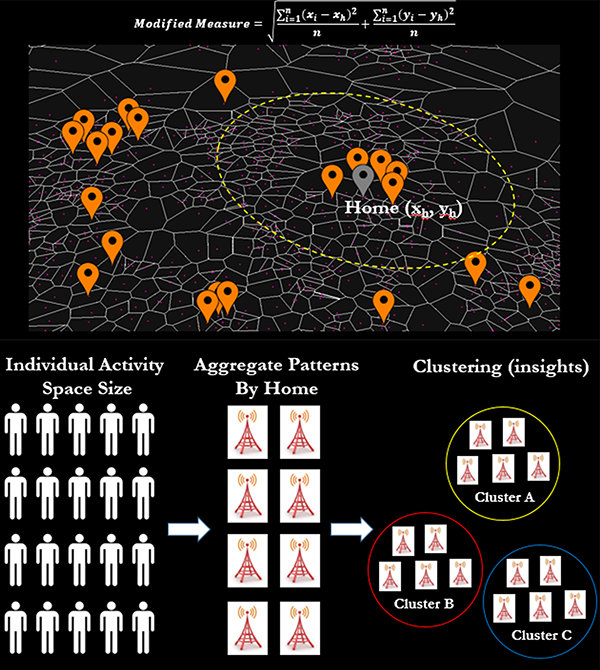
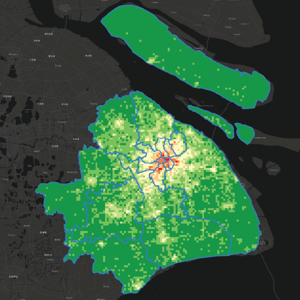
Mapping The Spatial Extent of Human Activity Space
How do people's daily activities take place around where they live? Do people living in different parts of a city exhibit different activity space sizes? By leveraging mobile call detail records (CDRs), we propose a home-based approach to quantifying the spatial extent of human activity space, and investigate how they are related to the socio-economic characteristics of the built environment.
Conducted at: University of Tennessee, Knoxville
Publications: Transportation (2015)
Visual-Analytic System For Complex Environmental Models
I develop a web-based visual analytic system to help environmental scientists better understand the software structures of large-scale environmetal models. The framework integrates data management, software structure analysis, and web-based visualizations.
Conducted at: Oak Ridge National Laboratory (ORNL)
Website: http://cem-base.ornl.gov/CLM_Web/CLM_Web.html
Publications: SERP (2014); EMS (2017); Procedia Computer Science (2017)
2024
[67]. Lin, Y., Xu, Y.*, Zhao, Z., Tu, W., Park, S. and Li, Q. Assessing effects of pandemic-related policies on individual public transit travel patterns: A Bayesian online changepoint detection based framework. Transportation Research Part A: Policy and Practice, 181, p. 104003. [PDF]
[66]. Su, S., Wang, Z., He, S., Xu, Y., Chen, Y. and Lan, T. Rethinking the theoretical genesis, research paradigm and research agenda of Geo-computational Social Sciences. Acta Geographica Sinica. 79(1): 187-205. [PDF]
2023
[65]. Medeiros, R.M., Duarte, F., Bojic, I., Xu, Y., Santi, P. and Ratti, C. Merging transport network companies and taxis in Curitiba’s BRT system. Public Transport. [PDF]
[64]. Chen, X., Xu, Y.*, Park, S., Chen, Y., Liu, X. and Zhuge, C. A Cross-Scale Representation of Tourist Activity Space. Annals of the American Association of Geographers, 113(10), pp.2333-2358. [PDF]
[63]. Yan, J., Naghedi, R., Huang, X., Wang, S., Lu, J. and Xu, Y. Evaluating Simulated Visible Greenness in Urban Landscapes: An Examination of A Midsize US City. Urban Forestry & Urban Greening, p.128060. [PDF]
[62]. Lin, Y., Xu, Y.*, Zhao, Z., Park, S., Su, S. and Ren, M. Understanding changing public transit travel patterns of urban visitors during COVID-19: A multi-stage study. Travel Behaviour and Society, 32, p.100587. [PDF]
[61]. Park, S., Zu, J., Xu, Y.*, Zhang, F., Liu, Y. and Li, J. Analyzing travel mobility patterns in city destinations: Implications for destination design. Tourism Management, 96, p.104718. [PDF]
[60]. Li, X., Xu, Y*., Zhang, X., Shi, W., Yue, Y. and Li, Q. Improving short-term bike sharing demand forecast through an irregular convolutional neural network. Transportation Research Part C: Emerging Technologies, 147, p.103984. [PDF]
2022
[59]. Yuan, Y. and Xu, Y. Modeling activity spaces using big geo‐data: Progress and challenges. Geography Compass, p.e12663. [PDF]
[58]. Park, S., Zhong, R. and Xu, Y. Understanding seasonal and diurnal variations of inter-city tourism destination network. Journal of Travel & Tourism Marketing, 39(4), pp.432-447. [PDF]
[57]. Huang, X., Zhao, Y., Wang, S., Li, X., Yang, D., Feng, Y., Xu, Y., Zhu, L. and Chen, B. Unfolding community homophily in U.S. metropolitans via human mobility. Cities, p.104533. [PDF]
[56]. Ren, M., Park, S., Xu, Y.*, Huang, X., Zou, L., Wong, M.S. and Koh, S.Y. Impact of the COVID-19 pandemic on travel behavior: A case study of domestic inbound travelers in Jeju, Korea. Tourism Management, p.104533. [PDF]
[55]. Li, M., Cao, S., Zhu, X. and and Xu, Y. Techno-economic analysis of the transition towards the large-scale hybrid wind-tidal supported coastal zero-energy communities. Applied Energy, 316, p.119118. [PDF]
[54]. Li, Q., Liang, S., Xu, Y., Liu, L. and Zhou, S. Assessing personal travel exposure to on-road PM2. 5 using cellphone positioning data and mobile sensors. Health & Place, 75, p.102803. [PDF]
[53]. Li, X., Huang, X., Li, D. and Xu, Y. Aggravated social segregation during the COVID-19 pandemic: Evidence from crowdsourced mobility data in twelve most populated U.S. metropolitan areas. Sustainable Cities and Society, p.103869. [PDF]
[52]. Yu, Z., Zu, J., Xu, Y.*, Chen, Y. and liu, X. Spatial and Functional Organizations of Industrial Agglomerations in China's Greater Bay Area. Environment and Planning B: Urban Analytics and City Science, p.23998083221075641. [PDF]
[51]. Huang, X., Xu, Y., Liu, R., Wang, S., Wang, S., Zhang, M., Kang, Y., Zhang, Z., Gao, S., Zhao, B. and Li, Z. Exploring the spatial disparity of home‐dwelling time patterns in the USA during the COVID‐19 pandemic via Bayesian inference. Transactions in GIS (in press). [PDF]
[50]. Yue, Y. et al., Integration Path of Spatial and Geo-Computing and Computational Social Science. Geomatics and Information Science of Wuhan University, 47(1): 1-18. [PDF]
[49]. Xu, Y.*, Zou, D., Park, S., Li, Q., Zhou, S. and Li, X. Understanding the movement predictability of international travelers using a nationwide mobile phone dataset collected in South Korea. Computers, Environment and Urban Systems, 92, p.101753. [PDF]
2021
[48]. Tu, W., Zhu, T., Zhong, C., Zhang, X., Xu, Y. and Li, Q. Exploring metro vibrancy and its relationship with built environment: a cross-city comparison using multi-source urban data. Geo-spatial Information Science, 25(2), pp.182-196. [PDF]
[47]. Guo, X., Cao, S., Xu, Y. and Zhu, X. The Feasibility of Using Zero-Emission Electric Boats to Enhance the Techno-Economic Performance of an Ocean-Energy-Supported Coastal Hotel Building. Energies, 14(24), p.8465. [PDF]
[46]. Jian, I.Y., Chan, E.H., Xu, Y.* and Owusu, E.K. Inclusive public open space for all: Spatial justice with health considerations. Habitat International, 118, p.102457. [PDF]
[45]. Li, Q., Zou, D. and Xu, Y.. Combining individual travel behaviour and collective preferences for next location prediction. Transportmetrica A: Transport Science (in press). [PDF]
[44]. Xu, Y.*, Santi, P. and Ratti, C. Beyond Distance Decay: Discover Homophily in Spatially Embedded Social Networks. Annals of the American Association of Geographers, 112(2), pp.505-521. [PDF]
[43]. Li, X., Xu, Y.*, Chen, Q., Wang, L., Zhang, X. and Shi, W. Short-Term Forecast of Bicycle Usage in Bike Sharing Systems: A Spatial-Temporal Memory Network. IEEE Transactions on Intelligent Transportation Systems , 23(8), pp.10923-10934. [PDF]
[42]. Yu, Z., Zhu, X., Liu, X., Wei, T., Yuan, H., Xu, Y., et al. Reopening International Borders without Quarantine: Contact Tracing Integrated Policy against COVID-19. International Journal of Environmental Research and Public Health, 18(14), p.7494. [PDF]
[41]. Yang, X., Fang, Z., Xu, Y., Yin, L. and Zhao, Z. Revealing temporal stay patterns in human mobility using large-scale mobile phone location data. Transactions in GIS, 25(4), pp.1927-1948. [PDF]
[40]. Xu, Y.* ., Xue, J., Park, S. and Yue, Y. Towards a multidimensional view of tourist mobility patterns in cities: A mobile phone data perspective. Computers, Environment and Urban Systems, 86, p101593. [PDF]
[39]. Kwok, C.Y.T., Wong, M.S., Chan, K.L., Kwan, M.P., Nichol, J.E., Liu, C.H., Wong, J.Y.H., Wai, A.K.C., Chan, L.W.C., Xu, Y. and Li, H. Spatial analysis of the impact of urban geometry and socio-demographic characteristics on COVID-19, a study in Hong Kong. Science of The Total Environment, 764, p.144455. [PDF]
[38]. Zhou, Y., Thill, J.C., Xu, Y. and Fang, Z. Variability in individual home-work activity patterns. Journal of Transport Geography, 90, p102901. [PDF]
[37]. Xu, Y., Li, J., Belyi, A. and Park, S. Characterizing destination networks through mobility traces of international tourists — A case study using a nationwide mobile positioning dataset. Tourism Management, 82, p.104195 [PDF]
2020
[36]. Xu, Y.*, Li, J., Xue, J., Park, S. and Li, Q. Tourism Geography through the Lens of Time Use: A Computational Framework Using Fine-Grained Mobile Phone Data. Annals of the American Association of Geographers, 111(5), 1420-1444. [PDF]
[35]. Xu, Y.*, Li, X., Shaw, S. L., Lu, F., Yin, L. and Chen, B. Effects of data preprocessing methods on addressing location uncertainty in mobile signaling data. Annals of the American Association of Geographers, 111(2), 515-539. [PDF]
[34]. Luo, Y., Xiang, L., Xu, Y. and Gui, Z. Road Network Extraction from GPS Trajectories — A Tensor Voting Based Algorithm. Proceedings of the GISRUK 2020, London.
[33]. Park, S., Xu, Y., Jiang, L., Chen, Z. and Huang, S. Spatial structures of tourism destinations: A trajectory data mining approach leveraging mobile big data. Annals of Tourism Research, 84, p. 102973. [PDF]
[32]. Tu, W., Mai, K., Zhang, Y., Xu, Y., Huang, J., Deng, M., Chen, L. and Li, Q. Real-time Route Recommendations for E-Taxies Leveraging GPS Trajectories. IEEE Transactions on Industrial Informatics, 17(5), pp.3133-3142. [PDF]
[31]. Zhao, P., Xu, Y.*, Liu, X. and Kwan, M.P. Space-time dynamics of cab drivers' stay behaviors and their relationships with built environment characteristics. Cities, 101, p.102689. [PDF]
2019
[30]. Xu, Y.*, Belyi, A., Santi, P. and Ratti, C. Quantifying segregation in an integrated urban physical-social space. Journal of The Royal Society Interface, 16: 20190536. [PDF]
[29]. Yu, H., Fang, Z., Lu, F., Murray, A.T., Zhao, Z., Xu, Y. and Yang, X. Massive Automatic Identification System Sensor Trajectory Data-Based Multi-Layer Linkage Network Dynamics of Maritime Transport along 21st-Century Maritime Silk Road. Sensors, 19(19), p.4197. [PDF]
[28]. Jia, T., Yu, X., Shi, W., Liu, X., Li, X. and Xu, Y. Detecting the regional delineation from a network of social media user interactions with spatial constraint: A case study of Shenzhen, China. Physica A: Statistical Mechanics and its Applications, p.121719. [PDF]
[27]. Yang, X., Fang, Z., Xu, Y., Yin, L., Li, J. and Lu, S. Spatial heterogeneity in spatial interaction of human movements—Insights from large-scale mobile positioning data. Journal of Transport Geography, 78, 29-40. [PDF]
[26]. Xu, Y.* and Ratti, C. Conquer the Divided Cities. Towards a New Enlightenment: A Transcendent Decade, pp.366-380, BBVA OpenMind, Spain. [PDF]
[25]. Xu, Y.*, Chen, D., Zhang, X., Tu, W., Chen, Y., Shen, Y. and Ratti, C. Unravel the landscape and pulses of cycling activities from a dockless bike-sharing system. Computers, Environment and Urban Systems, 75, 184-203. [PDF]
[24]. Liu, X., Xu, Y. and Ye, X. Outlook and Next Steps: Integrating Social Network and Spatial Analyses for Urban Research in the New Data Environment. Cities as Spatial and Social Networks, pp. 227-238. Springer, Cham. [PDF]
2018
[23]. Zhang, X., Xu, Y.*, Tu, W. and Ratti, C. Do different datasets tell the same story about urban mobility — A comparative study of public transit and taxi usage. Journal of Transport Geography, 70, 78-90. [PDF]
[22]. Zhu, J., Xu, Y.*, Shaw, S. L., Fang, Z. and Liu, X. Geographic Prevalence and Mix of Regional Cuisines in Chinese Cities. ISPRS International Journal of Geo-Information, 7(5), 183. [PDF]
[21]. Xu, Y.*, Belyi, A., Bojic, I. and Ratti, C. Human Mobility and Socioeconomic Status: Analysis of Singapore and Boston. Computers, Environment and Urban Systems, 72, 51-67. [PDF]
[20]. Xu, Y., Shaw, S. L., Lu, F., Chen, J., and Li, Q. Uncovering the relationships between phone communication activities and spatiotemporal distribution of mobile phone users. In Human Dynamics Research in Smart and Connected Communities, pp. 41-65, Springer, Cham. [PDF]
2017
[19]. Tu, W., Cao, J., Yue, Y., Shaw, S.L., Zhou, M., Wang, Z., Chang, X., Xu, Y. and Li, Q. Coupling mobile phone and social media data: a new approach to understanding urban functions and diurnal patterns. International Journal of Geographical Information Science, 31(12), 2331-2358. [PDF]
[18]. Fang, Z., Yang, X., Xu, Y., Shaw, S.L. and Yin, L. Spatiotemporal model for assessing the stability of urban human convergence and divergence patterns. International Journal of Geographical Information Science, 31(11), 2119-2141. [PDF]
[17]. Xu, Y.*, Belyi, A., Bojic, I. and Ratti C. How friends share urban space: An exploratory spatiotemporal analysis using mobile phone data. Transactions in GIS, 21, 468-487. [PDF]
[16]. Xu, Y., Wang, D., Janjusic, T., Wu, W., Pei, Y. and Yao, Z. A Web-based Visual Analytic Framework for Understanding Large-scale Environmental Models: A Use Case for The Community Land Model. Procedia Computer Science, 108, 1731-1740. [PDF]
[15]. Xu, Y., Wang, D., Iverson, C., Walker, A. and Warren, J. Building a Virtual Ecosystem Dynamic Model for Root Research. Environmental Modelling & Software, 89, 97-105. [PDF]
2016
[14]. Yang, X., Fang, Z., Xu, Y., Shaw, S-L., Zhao Z., Yin, L., Zhang, T. and Lin, Y. Understanding Spatiotemporal Patterns of Human Convergence and Divergence Using Mobile Phone Location Data. ISPRS International Journal of Geo-Information, 5(10), 177. [PDF]
[13]. Xu, Y., Shaw, S-L., Fang, Z. and Yin, L. Estimating Potential Demand of Bicycle Trips from Mobile Phone Data - An Anchor Point Based Approach. ISPRS International Journal of Geo-Information, 5(8), 131. [PDF]
[12]. He, H., Wang, D., Xu, Y. and Tan, J. Data synthesis in the Community Land Model for ecosystem simulation. Journal of Computational Science, 13, 83-95. [PDF]
[11]. Xu, Y., Shaw, S-L., Zhao, Z., Yin, L., Lu, F., Chen, J., Fang, Z. and Li, Q. Another Tale of Two Cities: Understanding Human Activity Space Using Actively Tracked Cellphone Location Data. Annals of the American Association of Geographers, 106(2), 489-502. [PDF]
[10]. Zhao, Z., Shaw, S-L., Xu, Y., Lu, F., Chen, J. and Yin, L. Understanding the Bias of Call Detail Records in Human Mobility Research. International Journal of Geographical Information Science, 30(9), 1738-1762. [PDF]
2015
[9]. Xu, Y., Shaw, S-L., Zhao, Z., Yin, L., Fang, Z. and Li. Q. Understanding aggregate human mobility patterns using passive mobile phone location data: a home-based approach. Transportation, 42(4), 625-646. [PDF]
[8]. Xu, Y., Shaw, S-L., Zhao, Z., Yin, L., Fang, Z. and Li. Q. Understanding Individual Daily Activity Spaces Based on Large Scale Mobile Phone Location Data. Proceedings of The 13th International Conference on GeoComputation. Dallas, Texas, USA.
2014
[7]. Wang, D., Xu, Y., Thornton, P., King, A., Steed, C., Gu, L. and Schuchart A functional test platform for the Community Land Model. Environmental Modelling & Software, 55, 25-31. [PDF]
[6]. Xu, Y., Wang, D., Janjusic, T. and Xu, X. A Web-based Visual Analytic System for Understanding the Structure of Community Land Model. Proceedings of The 13th International Conference on Software Engineering Research and Practice. Las Vegas, NV. USA.
[5]. Wang, D., Schuchart, T., Janjusic, T., Winkler, F., Xu, Y. and Kartsaklis. Toward Better Understanding of the Community Land Model within the Earth System Modeling Framework. Procedia Computer Science, 29, 1515-1524. [PDF]
[4]. Wang, D. and Xu, Y.. Software Engineering for Scientific Application: Effort Report on The Community Land Model within the Earth System Modeling Framework. Proceedings of The 7th International Congress on Environmental Modelling and Software. San Diego, CA, USA.
2012
[3]. Xu, Y., Shaw, S-L., Chen, J., Li, Q., Fang, Z. and Li, Y. Uncover Repeated Spatio-temporal Behavioral Patterns Embedded in GPS-based Taxi Tracking Data. Proceedings of The 7th International Conference on Geographic Information Science. (Extended abstract). Columbus, OH, USA.
[2]. Chen, J., Shaw, S-L., Xu, Y., Li, Q., Fang, Z. and Li, Y. Where and When Taxi Drivers Deviate from the Shortest Path in Their Route Choices: A Case Study of Wuhan, China. Proceedings of The 7th International Conference on Geographic Information Science. (Extended abstract). Columbus, OH, USA.
2011
[1]. Xu, Y., Li, Q. and Tang, L. Road Damage Detection from Remote Sensing Imagery Based on Road Network Vector Data (in Chinese). Bulletin of Surveying and Mapping, 4, 004. [PDF]
Research Assistant / Postdoctoral Fellow in Urban Analytics
I always welcome outstanding candidates to fill RA & Postdoctoral positions in the broad field of urban informatics and big data analytics. For interested applicants, please refer to the job description for more details.
Funded Ph.D. in Urban Informatics
I am currently seeking exceptional candidates to fill funded Ph.D. positions starting in Fall 2024. Applicants must hold an undergradate degree or higher in GIS & geo-informatics, computer science, urban planning, or related fields. Language requirements should be fullfilled (TOEFL & IELTS). For interested applicants, please contact yang.ls.xu@polyu.edu.hk.
Hong Kong Ph.D. Fellowship
I am always keen to work with outstanding applicants to compete for the Hong Kong Ph.D. fellowship. The awardee will be admitted to the full-time PhD program at PolyU, and the fellowship will provide a monthly stipend of HK$27,600, plus conference and research related travel allowance. The application closes on December 1st every year. More information can be found here.
@ 2016 Yang Xu, All Rights Reserved